
Wildflower Carpets of Carrizo Plain Superbloom
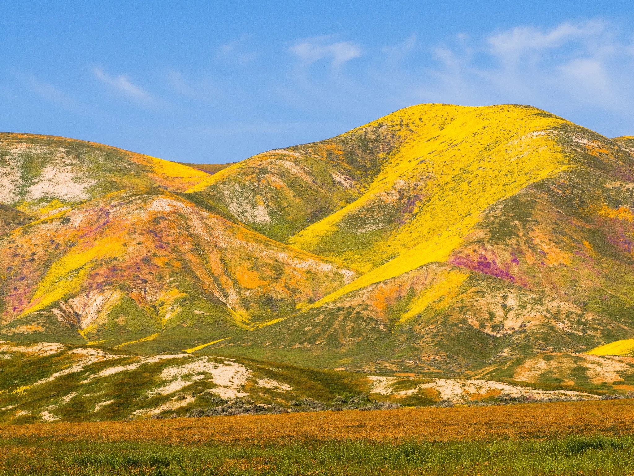
Golden Slopes of the Carrizo Plain Superbloom
Navigating the Carrizo Plain Superbloom
Thinking back to my first visit to Carrizo Plain National Monument in Central California, I clearly had no idea what I was doing. Even though I had read about the tremendous wildflower blooms and expected to find that, well, it just was not wildflower season and it was a desolate wasteland. Even the Ranger at the visitor center was surprised to see me arrive looking for wildflowers. I’m sure she thought I was a bit nuts for not having done a little bit of research first. Well, I did do my research and of course springtime is wildflower time so I went back a couple of years later when I was in the area specifically targeting the wildflower locations and I ran across just an unbelievable display of yellow and purple and orange up and down the length of this monument.
There’s one road that runs the full length of it, and if you look up Soda Lake Road, you will find it spans about 45 miles, connecting Highway 58 on the north end to Highway 166 on the south. About 18 miles of that main artery are unpaved. Which I did take, but I also ventured off onto the smaller two-track dirt roads in the van, which was a little bit dicey in some areas, but it did allow me to find many more beautiful displays of wildflowers. Now I know you don’t get these every year so if you wanna go, please do just a minimal amount of research first and see what kind of bloom they’re having and when the best time to go would be. There are two campgrounds there, but I didn’t stay at either one of them. They’re primitive with no hookups, no water. Instead, I simply found a wide spot on one of the two-track dirt roads big enough to pull completely off the road and had a lovely night surrounded by beautiful wildflowers.
Understanding the Landscape and History
Carrizo Plain is the largest single native grassland remaining in California, stretching roughly 50 miles long and up to 15 miles across in southeastern San Luis Obispo County. Flanked by the Temblor Range to the northeast and the Caliente Range to the southwest, the monument sits right over the active San Andreas Fault, which is clearly visible along features like Wallace Creek where stream channels have been visibly offset by tectonic movement. This remote basin feels entirely detached from the bustling coastal cities or the heavily farmed Central Valley just over the mountains.
Tips for Photographing Remote Deserts
Capturing vast desert spaces and sudden superblooms requires patience and a solid eye for composition. When working with sweeping hills blanketed in color, look for leading lines in the contours of the terrain or find a contrasting foreground element—like a dense patch of fiddlenecks or coreopsis—to anchor the frame. Because weather and rainfall dictate whether you will find a sea of gold or barren earth, checking recent satellite data or calling local BLM offices saves you from repeating my early mistakes. Treat these fragile environments with respect, stay on designated tracks, and always pack in every drop of water you will need for your stay.
Explore More of My Adventures
Discover the quiet beauty of a hidden northern California redwood creek, captured with an OM-1 camera amidst lush ferns and mossy boulders.